Crisscrossing America's West in My RV
- Kent Burkhardsmeier

- Dec 8, 2021
- 7 min read
Updated: Aug 31, 2022
travel stories with landscape photographic artist
kent j burkhardsmeier
9 more miles

Table of Content
—> Seattle Time
—> Oregon Trail
Crisscrossing the Trail—Seattle to Denver

The term that best summarizes my September adventures would be crisscross—
form a pattern of intersecting lines or paths on (a place).
Departing Seattle at summer's end, I headed in an easterly direction through Oregon, Idaho, and Wyoming, again
As I traversed these states, I recrossed Snoqualmie Pass, crossed over the Columbia and Snake Rivers, and re-encountered the Oregon Trail in addition to crossing lava flows and passing through nuclear orbits. Like the Continental Divide, these geographic features meander across the American West—so, I too, meandered along the American West roadways.
Reaching Denver by September 24th was the objective. I needed to rendezvous for a solar installation upgrade on Whispers—work scheduled since the beginning of August.
Summer's End
(August 25 - September 10)
Seattle (WA) Plymouth Park (WA)

To commemorate summer's end to my adventures, I celebrated with family by enjoying liquid nitrogen infused drinks at Seattle Space Needle's Loupe Lounge.
The first Monday in September marks the U.S. national holiday, Labor Day—honoring the American labor movement and contributions of the working class.
Many Americans seemed to have forgotten the relevance of the day—whereas nowadays it signifies: (a) big retail sales opportunities, (b) the beginning of a new school year, (b) closing of swimming areas, and (d) marking the “end” of summer. This year it marked, ending quality family time and turning eastward for the next leg of my photographic travel adventures.

Leaving Seattle, I headed east-southeast to Plymouth Park, a Corp of Engineer campground on the shores of the Columbia River along the Washington-Oregon border. If you recall, at the end of August, I stayed at a Washington State Park on the Columbia River.
Several nights at Plymouth Park provided an opportunity for Whispers and me to refamiliarize ourselves. She spent 2.5 weeks parked in a semi-vacant cruise ship parking lot in Seattle while I stayed with family.
Happy Trails, Again
(September 10 - 16)
Glenns Ferry (ID) Idaho Falls (ID)
Jackson (WY)

For good reason, I christened the truck “Criss.” Most of my routes involve crossing previously covered routes and features. In essence, I’m crisscrossing America as I capture whispers from nature.
The day’s drive from Plymouth Park to Glenns Ferry exemplifies this, as I crossed the Columbia River (again) into Oregon (again). We cut across Oregon until we connected onto US 395 (again). There, we passed through the land of Ore Ida and Tater Tots (again) driving alongside the Snake River (again). After passing by Walcott State Park off of I-40 (again) I arrived at Three Island Crossing State Park in Glenns Ferry (ID).
Close friends had invited us to visit them at their Jackson (WY) condo, but I wasn’t able to find a suitable campsite or RV park near Jackson. So, I booked a campsite for Whispers in Idaho Falls. While she rested and enjoyed some solo time, I drove to Jackson. After staying with them for a couple nights I returned to pick up Whispers and crisscrossed back through Jackson, Wyoming.

Oregon Trail
Three Island Crossing—one of the most treacherous river crossings on the Oregon Trail occurred near present-day Glenns Ferry State Park.
The Snake River was difficult and dangerous as described by these diary records:
On August 13, 1836, Narcissa Whitman wrote in her diary, "Two of the tallest horses were selected to carry Mrs. Spaulding and myself over. Mr. McCleod gave me his and rode mine. The last branch we rode as much as half a mile in crossing and against the current, too, which made it hard for the horses, the water being just to their sides. Husband had considerable difficulty in crossing the cart. Both cart and mules were turned upside down in the river and entangled in the harness. The mules would have been drowned but for a desperate struggle to get them ashore. Then after putting two of the strongest horses before the cart and the men swimming behind to steady it, they succeeded in getting it across. I once thought that crossing streams would be the most dreaded part of the journey. I can now cross the most difficult stream without the least fear."
On September 11, 1843, William T. Newby ". . . crossed Snake Rive[r]. First we drove over a part of the river one hundred yards wide on to a island, the[n] over a northern branch 75 yards wide on a second island; then we tide a string of wagons together by a chane in the ring of the lead cattles yoak & made fast to the wagon of all a horse & before & him led. We carried as many a[s] fifteen wagons at one time. . . . The water was ten inches up the waggeo[n] beds in the deepe places."
After reading these accounts, I decided it best to stay on shore and not attempt a river crossing with/or without my modern era wagon and horse (i.e., Whispers and Criss).

Craters of the Moon Infused. . .

Amidst the high desert of southern Idaho sits a “vast ocean of lava flows” known as Craters of the Moon National Monument & Preserve.
When you pause, soften your vision, and enter the presence of the park, you can sense the moving lava flows. Black, hardened lava interspersed with pine bushes and sagebrush fills the landscape.
Tiny bouquets of white lava phlox bloom across black lava pebble fields like illuminated white clouds across a black moonless night.
. . . with Nuclear Power
Further along US Hwy 20, sits the history making town: Arco (ID)—population 995. On December 20, 1951, the U.S. Government switched on an experimental breeder reactor (EBR-1)—the world’s first! It was located southeast of Arco at the National Reactor Testing Station (NRTS). EBR-1 was the first peacetime use of nuclear power in the world and the first to use plutonium fuel. Then, on July 17, 1955, Arco became the world’s first city lit by atomic power! Arco’s atomic power was supplied by an experimental boiling water reactor (BORAX-III).
Unfortunately, on January 3, 1961, three military enlisted personnel working on an experimental reactor (SL-1) at the NRTS were killed when a control rod was pulled too far out of the reactor, causing an explosion. It was the only fatal nuclear incident in the U.S.
You can take a self-guided nuclear power plant tour of EBR-1 to see the first light bulbs lit by atomic power and look into the first “hot cell”— resultant of a partial meltdown.

Tetons, Eagles, and Flyfishing
(September 16 -24)
Debois (WY)
East of the Grand Teton National Park on the other side of the Continental Divide at Togwotee Pass, along US-26 sits the rustic, old west town of Dubois. Original residents wanted the town named Never Sweat but the U.S. Postal Service didn’t’ accept that name! (Can you imagine how Proctor & Gamble would have used the town for marketing deodorant?). Instead, the Postal Services named it Dubois— after, then Idaho Senator Fred Dubois. Residents protested by pronouncing the town’s name like DU boys rather than the French pronunciation du BWA!
The lively Wind River saunters through town, drawing in campers, canoers, kayakers, and fly fishers. Dubois also provides a great hub for visiting the nearby scenic area—it is only an hour drive from Grand Teton National Park and 1-3/4 hours from Yellowstone National Park.
Famous outlaw, Butch Cassidy owned a ranch on the outskirts of Dubois. Butch Cassidy and his partner-in-crime were made famous by the movie starring Paul Newman and Robert Redford: Butch Cassidy and The Sundance Kid. [Note: back in July, we stayed in Sundance (WY)—the namesake town for the Sundance Kid.]

Former Florida neighbors joined us in Dubois as we camped alongside the Wind River. While they flyfished, I ventured out into the surrounding area and back into the Grand Teton NP for some photography.

Each morning, nature visited our campsite area. One morning, a bald eagle perched himself atop a poplar tree overlooking the Wind River.


September was a perfect time to witness the quaking of aspen trees and foliage changing colors.

Divided Continental Divide

A continental divide delineates a natural occurring boundary separating continental river systems. The Continental Divide of the Americas separates the watersheds flowing into the Pacific Ocean from those draining into the Atlantic or Artic Oceans. It runs from Cape Prince of Wales, Alaska to Tierra del Fuego, Argentina. It is known as the Great Divide, Western Divide, or simply the Continental Divide
Within the contiguous USA, some call the Continental Divide the “backbone of the Nation.” The water on one side flows to the Atlantic Ocean while water on the other side flows to the Pacific Ocean.

But this “backbone” splinters in the middle of Wyoming creating a “hole” in the Continental Divide.
Traveling on U.S. 287 from Dubois, I once again crisscrossed the Continental Divide, entering into the Great Divide Basin—the little bit of water that falls in this area never flows out of Wyoming.

U.S. Highway 287 between Fort Washakie (WY) and Rawlins (WY) is also known as the Chief Washakie Trail—named after the great Shoshone leader Washakie. Chief Washakie was friends with trapper and legendary mountain man, Jim Bridger (who, you’ll recall, was part of the first Rendezvous).
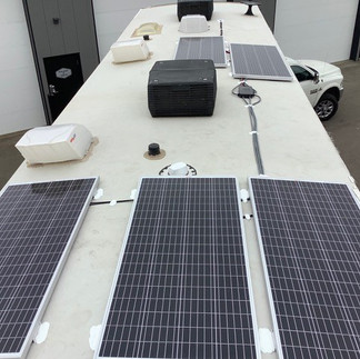
Solar Installation
(September 24 - 29)
Lafayette (CO)
My route proceeded to Denver, Colorado where I met up with RV solar specialists: David and Roland from Camping Express LLC (dba SolarPowerMyRV). David and Roland installed 1000 Watts of solar panels, 600mAh of lithium batteries, an inverter/converter, solar control unit, and all the necessary components on Whispers,


During the installation, I stayed with family, visited friends, explored LoDo, and revisited my alma mater (University of Colorado).

Now that Whispers has an added solar system, it is time to test out several days of boondocking. Stay tune for October’s travel adventures to see how boondocking worked out.

Tetons—forever
morning passes to witness.
I'm frozen, in awe!
Feel free to share a story from your journeys. in the comment section.
Or, add a comment on connecting with nature.

how much longer?
are we there yet?
how far to the next rest area?
“9 more miles”
9 more miles segment is a place where I share random road tidbits along the way during my capturing whispers from nature adventures.
In case you are wondering "are we there yet?"
“just 9 more miles"


Excellent adventure!! Awesome images!! Inspiring narrative!!